

The dispute over the South China Sea has been thrust back into the spotlight amid increasing tension between the Philippines and China in the disputed waters.
On Sunday, there were two near collisions close to Second Thomas Shoal, which lies within Manila’s Exclusive Economic Zone (EEZ), in the most serious incident this year.
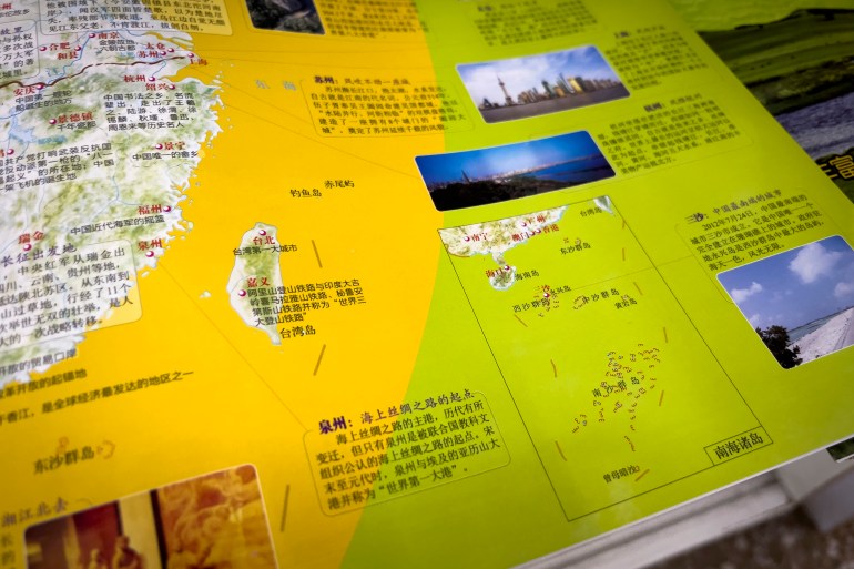
Beijing claims Second Thomas Shoal and almost the entire sea on the basis of its so-called “nine-dash line”, which it again featured in a new version of its national map earlier this year.
The map caused upset among Southeast Asian countries, including Malaysia, the Philippines and Vietnam, which also claim the waters nearest to their coasts.
An international tribunal ruled as far back as 2016 that the map provided no legal basis for China’s claim, but Beijing has ignored that decision and continues to insist on the line’s legitimacy.
According to the Sydney-based Lowy Institute, world powers like China use representational mediums like national maps to “justify their exceptionalism”.
The map allows Beijing to convey its “maritime territorialisation”, the think tank said.
Here’s all you need to know about the infamous nine-dash line and the long-running maritime dispute.
Historical waters
As far as China is concerned, its claim to the South China Sea can be traced back centuries and is embodied in the nine-dash line.
Voyages through the South China Sea can be dated back to the second century, during the Han Dynasty, when emperors sent out explorers and government officials to investigate other parts of Asia.
By the Song dynasty, China maintained that it was naming and claiming territory in the island chains it calls Nansha (the Spratly Islands) and Xisha (the Paracel Islands).
Trade also took Chinese explorers further into maritime Southeast Asia, including Indonesia, Borneo and the Malay peninsula, mostly famously under Admiral Zheng He during the Ming Dynasty.
Beijing insists that its historical records show the then-powerful Chinese dynasties enjoyed near total control over the waters for centuries.
However, the arrival of Western explorers and the rise of the Vietnamese Nguyen dynasty in the 19th century challenged China’s claims over maritime Southeast Asia.
The eleven-dash line
Tempted first by the lucrative spice trade, the Europeans began establishing themselves in Southeast Asia from the 16th century.
After the Portuguese established a colony in Malacca on the Malayan peninsula, the British, Dutch and French also began to expand into the region, setting up colonies that lasted until World War II and, in some cases, beyond.
Many cities in China were also controlled by Japan, a then-militarised country that also took control of the Korean peninsula in the early 20th century.
By 1942, the Japanese had pushed out the Europeans and expanded their rule into mainland and maritime Southeast Asia, occupying many countries surrounding the South China Sea.
When Japan surrendered three years later, the then-Nationalist government of China (known as the Republic of China) seized the opportunity to stake its claim to the waters and published a national map of China in 1947, including an eleven-dash claim to the South China Sea.
The nationalists were in the midst of fighting a civil war with the rapidly growing communist party, but geological experts began cataloguing what the Kuomintang government considered China’s maritime treasures.
The two extra dashes on the map included Vietnam’s Gulf of Tonkin.
When the communists won the civil war, Beijing revised the national map, apparently abandoning the claim to the gulf (and the two lines marking the waters) due to its shared “comradeship” with North Vietnam, which was also communist.
Taiwan, where the nationalist government set up an administration following its defeat to the communists, dropped its claims to those historical waters in 2005.
Modern conflicts
The U-shaped, tongue-like line on the Chinese national map reached deep into the South China Sea; a visual representation of China’s professed right to waters sometimes hundreds of kilometres from the Chinese coast.
The other countries that claim parts of the sea and reject the nine-dash line say the Chinese claim encroaches onto their territory as defined by the United Nations Convention on the Law of the Sea (UNCLOS). Under that law, each country has an EEZ extending 200 nautical miles (around 370km) from their coast over which it has sovereign rights.
The Association of Southeast Asian Nations (ASEAN) has long been trying to conclude a code of conduct to reduce tensions over sea claims, but it has made scant progress since 2002 when a preliminary code was agreed.
In the 20 years since, China has reinforced the map with more concrete signs of its claim – building on rocks and islets and expanding its military facilities on these man-made outposts. It has also backed up its claims with ships from its coast guard, maritime militia and fishing fleets.
What is so attractive about the South China Sea?
By the late 1970s, the South China Sea had become one of the world’s most prominent trade routes, and Southeast Asian nations were discovering potentially lucrative oil and gas deposits.
According to the Council on Foreign Relations, “… the sea’s estimated 11 billion barrels of untapped oil and 190 trillion cubic feet of natural gas – have antagonised competing claimants Brunei, Indonesia, Malaysia, the Philippines, Taiwan and Vietnam.”
UNCLOS was agreed in 1982 and was signed not only by the countries bordering the South China Sea but also by China.
However, despite signing the law, Beijing continued to assert its sovereignty.
For example, in the UN’s archival end-notes: “On 12 June 1985, the Secretary-General received from the Government of China the following communication: ‘The so-called Kalayaan Islands are part of the Nansha [Spratly] Islands, which have always been Chinese territory. The Chinese government has stated on many occasions that China has indisputable sovereignty over the Nansha Islands and at the adjacent waters and resources.’”
Often it has done more than send diplomatic notes.
“In the 1970s and 1980s, China took over control of much of the Paracel Islands in the northern SCS [South China Sea] and Johnson South Reef in the Spratly Islands in the southeast quadrant of the SCS, both in Vietnam’s EEZ,” the United States department of defence wrote.

Tussles between China and other claimant countries have continued ever since, with many accusing Beijing of unlawfully encroaching into their EEZs.
In 2012, Beijing took control of Scarborough Shoal within the Philippines’ EEZ after a months-long standoff involving paramilitary ships.
In October, the two were at loggerheads over the reef again – with the Philippines removing a Chinese string of buoys that were preventing its fishermen from doing their work.
Even before Sunday’s incident, there had been numerous encounters between Beijing and Manila off Second Thomas Shoal, where the Philippines grounded the Sierra Madre in 1999 and which lies more than 1,000km from China’s nearest major landmass of Hainan island.
In August, the Philippines accused China of “dangerous manoeuvres” after its coast guard sprayed water cannons at Filipino boats trying to resupply those stationed on the Sierra Madre. Earlier this year, it accused China of directing a “military grade laser” at the ships.
China claims that its land reclamation on the waters’ rocks and reefs generates maritime entitlements.
UNCLOS says that while states are allowed to build artificial islands within their own EEZ, they “do not possess the status of islands. They have no territorial sea of their own and their presence does not affect the delimitation of the territorial sea, the exclusive economic zone or the continental shelf”.
Arbitration Ruling
After the confrontation at Scarborough Shoal, the Philippines began arbitral proceedings against China at the Permanent Court of Arbitration in The Hague.
The court ruled in the Philippines’ favour, concluding that UNCLOS “superseded any historic rights or other sovereign rights or jurisdiction in excess of the limits imposed therein”.
In other words, the nine-dash line provided no basis for China’s expansive claims.
However, the ruling has done little to rein in Beijing. It has continued to build islands and deploy the coast guard, fishing boats, and maritime militia in the disputed waters.
After the latest clash over the Scarborough Shoal buoys, there was no sign of contrition in Beijing.
After referring to the shoal by its Chinese name – Huangyan Island – Ministry of Foreign Affairs spokesman Wang Wenbin issued a warning: “We advise the Philippines not to provoke or stir up trouble.”
With Beijing’s growing assertiveness and uncompromising attitude, it is hard to see it abandoning the nine-dash line anytime soon.
Sumber: www.aljazeera.com